
In the landscape of the American roadway, four colors seem to reign supreme for background signage: green, yellow, orange, and blue. Green (with white lettering) is the status quo across freeways and most municipal markers for value-neutral guidance and wayfinding. Yellow (with black lettering) is most pervasive in signaling a permanent aberration: e.g., a change in the elevation of a road, its bearing, or lane merges, all of which intend to break a driver from a numbed complacency, especially if he or she is unfamiliar with the roadway. Whether a local or a visitor, yellow communicates to drive cautiously and slowly, because the road conditions ahead are not ideal. Meanwhile, orange backgrounds (again with black lettering) represent a temporary aberration intended to alert locals and visitors equally: they signify an unexpected place for construction, a detour, or any radical change in traffic patterns. The critical difference is that the condition is short-term. Less common (but hardly rare) is blue (with white lettering), which has almost morphed into “none of the above” for informational signage, often indicating attractions or private businesses of particular interest to a visitor; I covered this blue semantic fuzziness last year, since these attractions can be permanent (historic landmarks) or unpredictably short-lived (a restaurant). The focus of this article is indeed the semiotics of the roadway, but it’s time to pan the gaze downward to the road itself, where stripe colors are more streamlined: white demarcates a general message of permission (what is allowed), yellow conveys a message of limitation (what is restricted), and most other colors are rare. It’s those rarities that interest me…which pivots the camera lens back to blue—specifically, to blue stripes on the pavement.
Road stripes have a dedicated place in car culture, but the palette is narrower. The overwhelming majority are white or yellow. On the American roadway, white typically divides the paving surface into subunits, but two adjacent subunits have the same function: lanes in a multi-lane arterial, each guiding traffic flowing the same direction. A one-way street will exclusively feature dashed white stripes in the roadway. They’re the most common color for conventional parking bays as well, while stripes perpendicular to a road’s direction of travel usually demarcate the place where a car should idle or stop (often at a pedestrian crosswalk, which typically but not always means more white stripes). Meanwhile, yellow stripes reflect subunits with differing functions, thereby implying a stricter standard or restriction in crossing the stripe. Any American roadway with yellow stripes indicates two directions of travel. Yellow is the typical color implying some restrictions for parking, either on a curb or sometimes on lots.
So what about those blue stripes? Most American motorists may have to ponder a bit to come up with a single answer. However, those with handicapped parking permits know exactly where blue stripes come into play; handicapped parking spaces (or the handicapped symbol itself) often feature some distinguishing blue, which is by far the most common deployment of the color on concrete or asphalt. Other uses are so rare that they even left me scratching my head. Like this one:
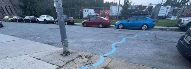
The first conclusion one might draw is: “It’s obvious why Public Works Departments don’t use blue more often. It doesn’t stand out as well as yellow or white.” It’s hard to deny this strange road indicator is striking less for its color than for the unusual, almost erratic curvy pattern: like a sine wave executed poorly. The shape and character is so atypical for a roadway that it is far more of the attention-getter than the blue stripe itself.
There’s got to be a story behind it, right? The blue stripes in question here come from the trendy Remington neighborhood in Baltimore, and I’ll confess that the above photograph isn’t entirely honest: I cropped it to highlight the mystery. Here’s a more complete depiction:
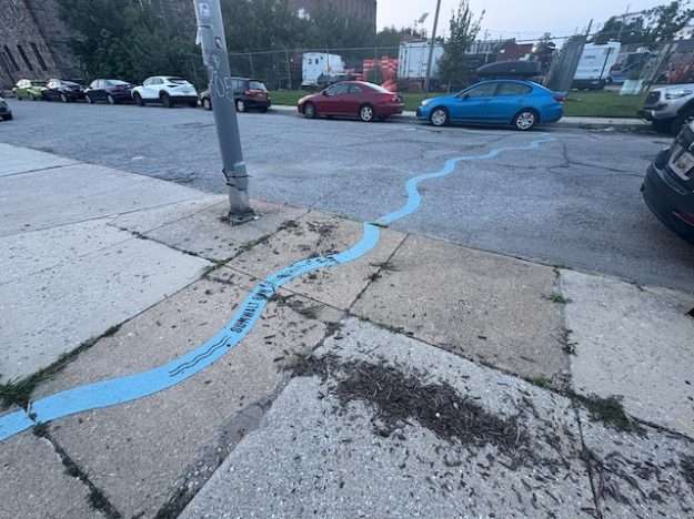
The mulch and cracks in the sidewalk obscure the lettering somewhat, but it says “SUMWALT RUN”, flanked by curvy parallel lines—an almost universal symbol of water. The fact that the blue stripe climbs the curb onto the sidewalk indicates that it is more than just a marker for motorists.
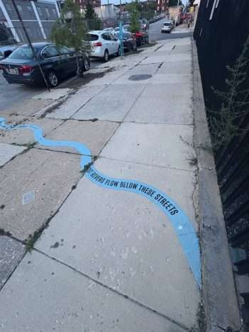
The statement on this blue stripe—“LOST RIVERS FLOW BELOW THESE STREETS”—isn’t cryptic to the average urban historian, but how many of those are really out there? For the uninitiated, it just sounds like poetry. I certainly won’t claim to be an urban historian, and while my suspicions proved well-founded, it took a little digging to corroborate beyond the clues. In the Mid-Atlantic, the word “Run” preceded by a proper name is a fairly common term for a tributary to a larger creek or river. Northern Virginia is filled with them: Hooffs Run, Four Mile Run, Holmes Run, and so forth. A century ago, “Sumwalt Run” was a stream that meandered throughout what at the time were the outskirts of Baltimore. Its source was Charles Village, a neighborhood adjacent to Remington that, like Remington, enjoys a heavy association with Johns Hopkins University to the immediate north. Sumwalt Run flowed to Jones Falls, another creek who at its mouth serves the easternmost slip in Baltimore’s famed Inner Harbor. While Jones Falls largely survives as path that parallels Interstate 83 in Baltimore (nicknamed “Jones Falls Expressway”), Sumwalt Run was less fortunate.
A recent article from Hopkins covers its history: as the Olmsted Brothers responded to a 1902 commission to improve the park system, unchecked development nearby already had channelized portions of Sumwalt Run to underground culverts, making room for what was the brand-new community of Charles City. This initiative thwarted the brothers’ plan to integrate Sumwalt Run into Wyman Park (which eventually formed the western border of the Hopkins campus. So, from 1907 to 1914, the Olmsteds buried the rest of its meandering three-mile course, enabling further development of the Remington neighborhood. With portions of Sumwalt Run flowing up to forty feet below street level, it is but an anecdote in the geography of the city, at least until 2020.
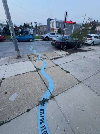
And thus, the blue stripes in Baltimore have revealed their function: they are histrorical and artistic, but not a tool for traffic management. The City commissioned local artist Bruce Willen to create a permanent linear tribute to Sumwalt Run called Ghost Rivers. The blue stripes iterate across a 1.5-mile path tracing much of the length of this now underground stream, offering markers and wayfinding signage to explain what happened. Willen chose the same shade of blue that “references the hue of waterways found on vintage maps”; it also helps avoid confusion with other blues or pavement markings. It is distinct without being alarmist. Furthermore, the gentle sinuousness and imperfect linearity—it traces the “ghost river”, which does not flow in a straight line—immediately suggests to the untrained eye that this is not a cautionary symbol. Perhaps most importantly, it raises a question about prior urban engineering initiatives—was burying Sumwalt Run and other Baltimore streams the right decision?—without steering the onlooker to a clear answer. It’s there to inform and to nudge more questions, but not to editorialize.
In most respects, I’ll assert that it’s a more effective deployment of blue stripes than this next example a hundred miles away.
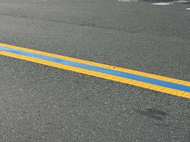
Does it even show up? The more conventional striping is plain to see: a double yellow line indicates a two-way street where, thanks to the lack of dashes in the stripes, passing is not allowed. In between the two yellow lines is a stripe of deep blue—evidence, once again, why blue stripes are not pervasive or desirable at commanding a motorist’s attention. My guess is most people wouldn’t notice it, but it’s a permanent fixture here on Main Street in Luray, Virginia, even at a white crosswalk.
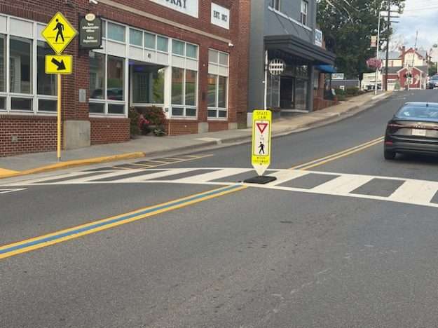
My initial, dead wrong assumption was that it represented some scenic path through the Blue Ridge Mountains. Come on: this is Luray, Virginia, the heart of the Shenandoah Valley. And while Shenandoah Valley National Park is indeed a part of the Blue Ridge Mountains, which stretch northward into Pennsylvania and south to the Great Smoky Mountains of North Carolina and Tennessee, the Blue Ridge Parkway in Shenandoah Valley links with Skyline Drive, which runs about ten miles east of Luray.
The blue stripes on Main Street Luray are, most likely (I cannot confirm), representative of the “Thin Blue Line” between order and chaos; a symbol most common in flags, but deployed strategically (and often subtly) as a gesture of respect to law enforcement officers. The blue stripes on a road like Luray are not compliant with Manual on Uniform Traffic Control Devices (MUTCD), which stipulates that no markings should exist between double stripes; the pavement must be visible to offer uniform contrast. That said, dark blue stripes have become canon in some parts of the country, not just honorary but as a wayfinding tool leading to the closest police station. Attempts to harness FHWA rules to eliminate them have elicited strong resistance, and, viewed in the context of other politically charged pavement markings, these blue stripes elicit little confusion or consternation among motorists. Most people, I suspect, don’t notice them; I’d imagine I’ve seen them many times prior to Luray and they didn’t even register.
Blue is a soft, cool color, perhaps the ideal hue for signifying something interesting but non-essential. Its comparative non-assertiveness may explain why it’s such an effective catch-all for road signs. Lost rivers, law enforcement, and Lenny’s Sub Shop.

5 thoughts on “Blue stripes on roads aren’t common. So what do they mean?!”
Interesting story, but it’s sad an artist was hired to paint squiggly blue lines that most likely will not last through the winter, especially on snow-plowed streets. Signage explaining the history of the underground river as you provided would make more sense.
Apparently the blue squiggles have been there since around 2020, so they look about as good as one might expect. Not sure they used the same caliber of paint we see for yellow dashes and whatnot. Do those get replaced every 5-6 years?
There are signs at various other places along the 1.5-mile path. but I haven’t seen them. In fairness, though not in great condition (and probably not the easiest thing to maintain), the blue stripes are at least something different and more attention getting for being atypical. Interpretive cultural signage is so widespread I could easily see it getting lost in the clutter. The combination of the striping–showing the exact underground path–and signage that explains is probably the best way to maximize awareness.
Your hometown did this to demarcate the route of Pogue’s Run through downtown. (The creek was buried in a brick sewer, and later a box culvert, where it remains until it drains into White River.)
A little bit of the line is still visible in the area near the Jacobs Post Office and Lucas Oil Stadium.
In fact, the creek/culvert is part of the reason the stadium axis is tilted to the right of the north-south street grid…it passes the SE corner of the stadium and then continues west. (Old Bing Maps aerials captured the exposed culvert. It is above the stadium field level…which is why there is a retractable roof and no floor drains. Expensive to drain uphill.)
Interesting about the “tilt” to the stadium. I had honestly thought it had something to do with solar orientation. Given its retractable roof, I suppose the sun could really affect gameplay with the right angle.
I knew most of Pogue’s Run was underground, especially around Lilly Campus. Wasn’t a small neighborhood given that name, most of which Lilly has gobbled up, but few vestiges remain north and/or east of Babe Denny, where Meridian Street and Russel Road split? Perhaps I’m imagining things.
Pogue’s Run goes from creek to underground culvert a few feet east of where New York St. crosses the CSX tracks just east of I-65/70. It generally follows the rail viaduct south and southwestward to Union Station, where it diverts southward on Meridian to the ex-Lilly (now Rolls-Royce campus) where it makes a turn westward under the Rolls-Royce circle drive and proceeds westward under the Rolls building and parking garage, thence under the ramp of the Jacobs Post Office (just south of Merrill St.), thence under Capitol Ave. and the SE corner of Lucas Oil Stadium, thence west-by-southwest to its discharge into White River south of McCarty and Kentucky.
The artistic blue line (painted sometime in the late 90s or early 00s) followed the “original” (ditched) open watercourse across streets and sidewalks south of Union Station and westward along today’s Merrill St. Much of it was torn up in reconstruction (i.e. The Cultural Trail and various other street redos).
As to a “Pogue’s Run” neighborhood, when the creek was still daylighted south of Union Station, it ran where the culvert I described above now is, then turned south near Missouri St. through what we now call Babe Denny. I’ve never heard of a Pogue’s Run neighborhood definition, though, and there are literally only 4 or 5 homes left in that stretch of Meridian south of Rolls.