
Few people truly appreciated it until it was (nearly) gone. And now it celebrates its centennial. Across nearly 2,450 miles, Route 66 linked two of the nation’s largest cities, allowing uninterrupted automobile travel across the nation’s sparsely populated western interior for the first time ever. Prior to April 30, 1926, the date the American Association of State Highway Officials dedicated the various segments linking Chicago to Los Angeles (well, technically, to Santa Monica) into its numbered name, the only means of crossing those thousands of miles was by train, by an unclear network of various state and local roads (many unpaved), or by incipient, mostly chartered air travel. What John Steinbeck branded “The Mother Road” proved transformative both in times of dearth (a major conduit for Dust Bowl migration to California farm country) and abundance (the preferred path for reaching the West Coast during a leisurely vacation, or a permanent relocation).
This highway’s matriarchal reign was, however, comparatively short: within thirty years, President Eisenhower and his DOT was devising a more efficient network of limited-access highways that would link most major cities in each state, even if the state’s largest city barely surpassed 40,000 people. With the advancement of the Interstate Highway System through the Federal-Aid Highway Act of 1956, the considerably more robust network of limited access freeways quickly eclipsed Route 66, not just through more efficient methods of getting across the county, but, in many cases the upgrades from highway to freeway used the rights-of-way that Route 66 once claimed, fundamentally eliminating the old highway across much of its rural intervals.
Albuquerque is an exception. Of the large cities within the eight states through which the historic Route 66 passes, most of the segments no longer exist in any fashion that remotely resembles the pioneering culture that the hit song “(Get Your Kicks on) Route 66” first immortalized through Nat King Cole and Bing Crosby, both in 1946 (two separate recordings, as well as many subsequent covers). The highway helped to mainstream cross-country travel by car, in turn spawning the normalization of auto-oriented businesses (motels, emergency mechanic shops, diners, a petrochemical and gas station chain that continues to this day).
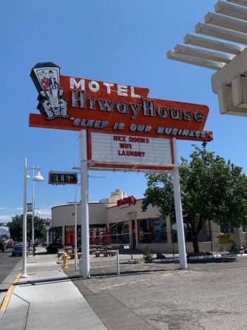
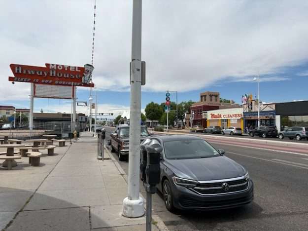
Though Route 66 remained the strongest path between two of America’s largest cities, it clearly only ameliorated access to only a tiny fragment of the Great Plains and Mountain West. The Bobby Troup-penned “Kicks” was the first time most Americans had heard of some of these communities, none of which were close to as populous as they are today. Now part of a metro of over one million, Albuquerque only had about 20,000 people in 1926. During the 40s, when postwar prosperity helped turn Route 66 into a cultural addiction, the Duke City nearly tripled in population.
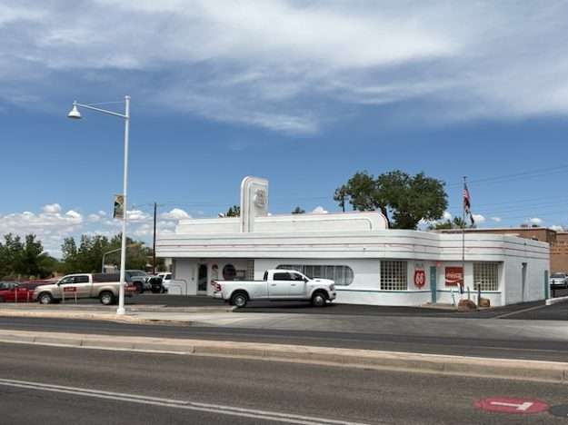
Meanwhile, Route 66 enjoyed about thirty-five years of preeminence. The 1956 Federal-Aid Highway Act initiated the renaming and conversion of various two- and four-lane highway fragments into limited access interstate freeways, networking to form that thorough (and still growing) Eisenhower Highway System. Most areas, urban and rural, lost the old-school automotive character through widening and access restrictions. Springfield, Missouri—the birthplace of the name “Route 66” and its ambitious transnational goal—has retained much of the portion going through its downtown, with signage and iconography banding together the east-west street segments of College Street, Saint Louis Street, Park Central, and the various other local segments that comprise the Mother Road. But Springfield isn’t that large in population or land area. (Conversely, the portion of Route 66 in Springfield, Illinois is largely gone.) Tulsa boasts many surviving portions of Route 66 as well—a stark contrast from nearby Oklahoma City—but they are fragments in neighborhoods and largely discontiguous. San Bernardino also claims a major portion, but contemporary development and upgrades have squandered so much of the historic feel that Route 66 guidebooks rarely recommend it for even the die-hard enthusiasts. Albuquerque therefore stands strong for having salvaged the largest portion of urbanized Route 66, at eighteen miles.
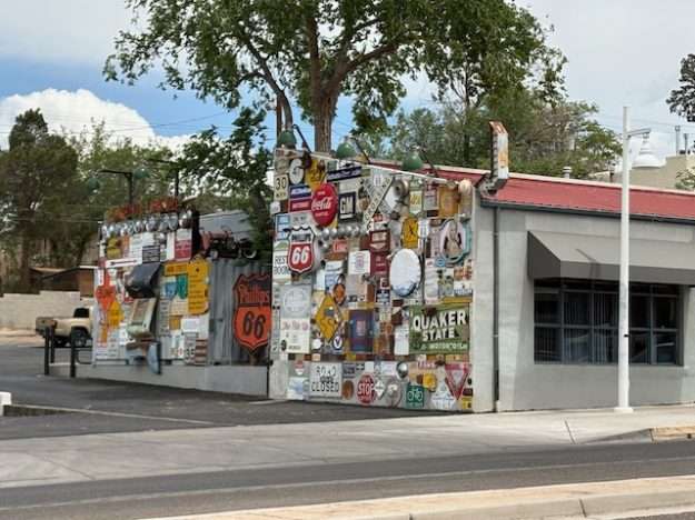
Now, at the centennial anniversary of the Mother Road, Visit Albuquerque (the city’s tourism and visitors bureau) has embarked on a tribute that, to the best of my understanding, surpasses anything that has taken place previously. As fragmented and diluted as the impact of Route 66 is in 2026, its cultural influence not just lingers but thrives; it’s a point of pride for a city to claim a portion of highway’s ROW within the municipal limits. The kickoff of centennial celebrations began 100 years to the day, with the hub of activities taking place in Springfield MO, the official host city and home to immaculate conception of the Mother Road. Albuquerque joined four other cities—St. Louis, Amarillo TX, Joliet IL, and Santa Monica CA—in prompting concurrent celebrations. Albuquerque then propelled the spirit of celebration throughout the rest of the year through Route 66 Remixed, a civic art series. Partnering with the experts at Santa Fe-based Meow Wolf, Remixed features twenty projects stretched across the eighteen miles of Central Avenue, the localized name for historic Route 66 as it bisects the city on a mostly latitudinal axis.
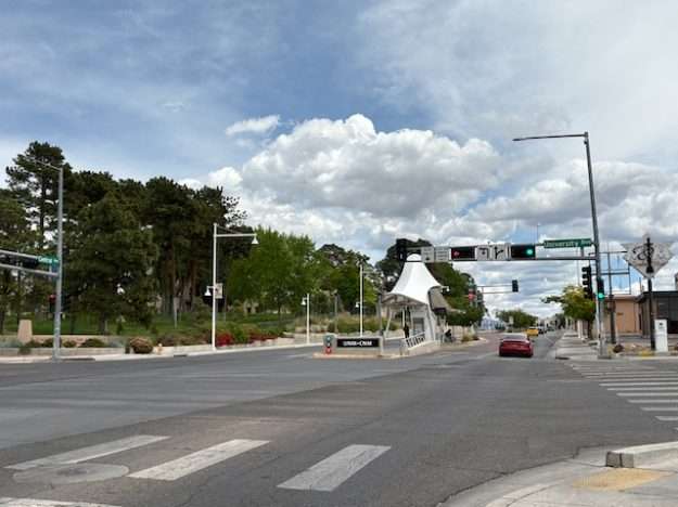
I lacked the time to explore much of Route 66 Remixed, so I lingered primarily near the University of New Mexico campus just east of downtown, in and around the Nob Hill neighborhood I’ve featured a few times over the years. This neighborhood apparently offered the highest concentration of installations. Here’s one at the fringe of the UNM campus, at the corner of Central Avenue NE and Pine Street NE.
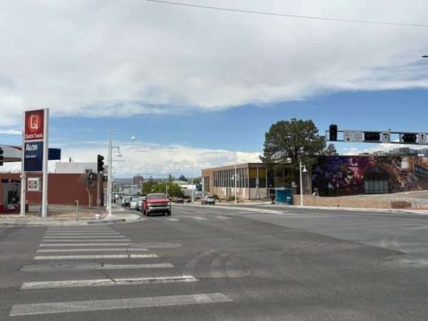
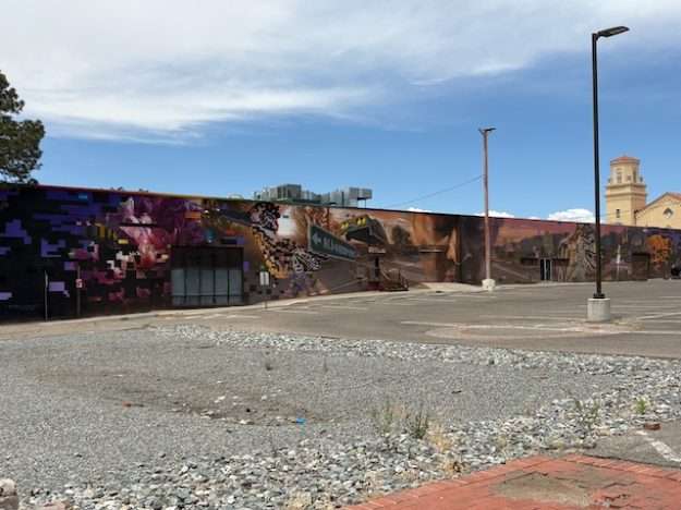
The installation is called Mother: Moment by two local artists, with sponsorship through UNM Arts Lab. Yes, it’s a mural: a civic art solution that has proven increasingly popular decades after Philadelphia largely birthed the idea through its Mural Arts Program, which I explored in the early days of this blog. I can’t effectively judge the size; it’s a mural, so of course it seems huge. The density of content and likely symbolism provide a feast for the eyes, which is much easier to appreciate when approaching slowly…by foot. Driving past this installation on this historically auto-oriented arterial endows this and the other Route 66 centennial celebrations with a bit of irony, since most passers-by will engage the civic art via the cars for which Route 66 initially intended to serve. That said, this stretch of Central Avenue NE bisects a student-rich area that is among the more pedestrian friendly in all of Albuquerque. And a quick view of this structure—the UNM Center for Advanced Research in Computing—prior to the mural proves that not only does the mural help spice up a previously drab flat wall, but the subject matter clearly evokes the academic mission within the facility.
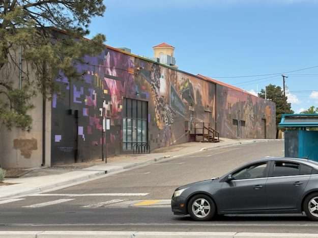
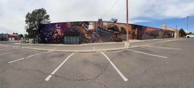
Down the street, a restaurant-dense portion of Central Avenue NE offers a more tactile installation.
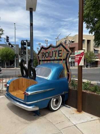
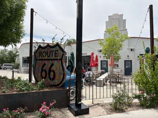
The Route 66 Car Throne, another tribute to the Mother Road’s centennial, involves the splicing of a 1951 Ford Flex (the model name seems dubious), so that the trunk becomes accessory seating, perhaps intended for people waiting for a table at the restaurant’s courtyard. As is the case with most of these installations, the artist has attached a poem to contextualize the art project, noting wryly how much of the time, peripatetic though we may be, we travel while seated. This installation straddles public and private, so that using the “throne” may constitute trespassing for those who aren’t patronizing the restaurant—which, incidentally, appears to be a repurposed old service station. Here’s a view from the easement-protected sidewalk along Central Avenue NE.
For my money’s worth—which, frankly, isn’t much since I’m reporting basically everything I had time to see—the most worthwhile centennial celebration isn’t an art installation at all.
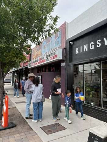
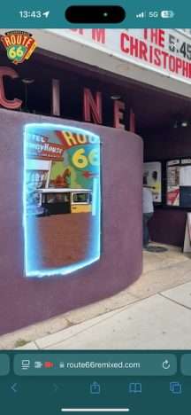
Just a stone’s throw and across the street from the Car Throne, a visual provocation exists exclusively through the careful positioning of a person’s smart phone at the target: on the rounded wall at the entrance to Guild Cinema. The project, …Let’s Not Forget, Albuquerque is a Character Too, involves augmented reality with the wall as a canvas, in a space largely fitting the old-school promotional movie posters that still decorate most theater exteriors. I hate to devote too much energy describing what eventually will likely not seem like a particularly novel concept, but the interplay of the website (Route 66 Remixed does not require downloading a separate app) on this old-time movie theater’s entrance wall allows a sumptuous visual feast while life and passers-by venture into and outside of the smart phone’s camera frame. It took a little bit of practice positioning the camera correctly, combined with caution not to step backward off the curb into old Route 66 traffic, but the end result is site-specific animation to honor the city with the greatest love for a preserved Mother Road at its centennial. I took a screen shot from my smart phone to offer a split-second sample of the result:
I didn’t intend to write an article exclusively to promote this civic art undertaking. After all, in terms of content, I’ve barely scratched the surface. I could easily see a return to Central Avenue NE to visit the remaining attractions—if I lived in Santa Fe or Amarillo or El Paso or even Flagstaff or Phoenix. I can’t say it’s justified from my perch over 2,000 miles to the northeast. This centennial celebration is, contrary to expectations, more distinctive at a micro level than macro. The idea of building new civic art projects to commemorate a watershed historic event (the macro) is nothing special; no doubt many other municipalities large and small along the old route have engaged similar artist commissions. What distinguishes Route 66 Remixed from others are the character, genre/style, and (especially in this case) the technological innovation involved in the installations themselves (the micro), all of which other cities can achieve in equal measure, because the sky’s the limit when human creative potential is concerned.
The bigger question–where micro lurches into macro—is the potential staying power of a centennial celebration. Five, ten, or even twenty years from now, will the various sculptures, murals, or augmented reality displays still survive at various intervals along Albuquerque’s share of the Mother Road? My guess is it will be like many other examples, including the hundreds of murals scattered throughout Philadelphia: the most beloved will enjoy a cultural embrace that morphs to advocacy in salvaging them, even if the building or retaining wall or service-station-cum-restaurant finds a new life. And Route 66 has already proven its staying power. Just ask this Burque veterinarian elsewhere on Central Avenue NE:
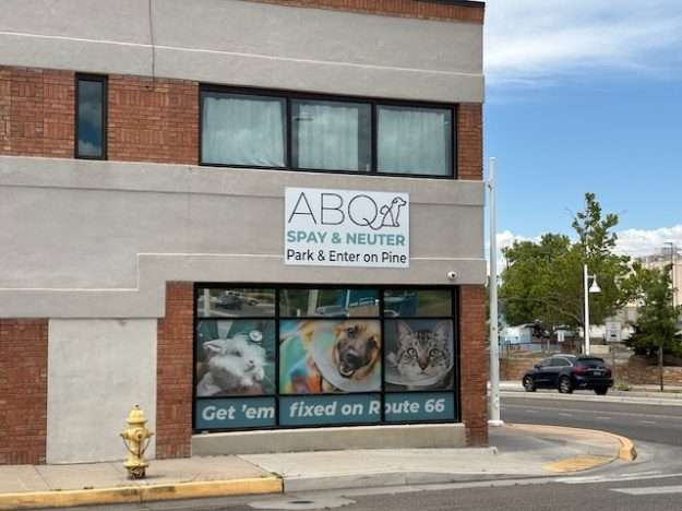
Maybe a certain rabbit probably shouldn’t have taken a left turn at Albuquerque after all.

16 thoughts on “Centennial celebration: Route 66 gets its kicks, through a remix.”
Thanks for sharing these.
I must admit the installations in Albuquerque for Route 66 are not impressive. It is a worthy centennial to recognize, but these examples would not encourage a visit to Albuquerque. Maybe you have to be there in person to appreciate the art.
Anybody from the city want to defend the installations?
Fair enough. The mural at least is pretty impressive for its size and level of detail, though it’s awfully busy. The split car is playful “found art” but not too eye-catching. And the augmented reality is more interesting for its novelty; if AR catches on, I’m sure later iterations will be much more impressive than this was.
I guess I should have seen all 20 installations…if I had had the time. That said, if the next three were at this same level or less impressive, I probably wouldn’t have felt impelled to bother visiting all of them. After all, they’re scattered across nearly 18 miles. And that’s the bigger selling point for Albuquerque: no other city has as much that is contiguous and well preserved.
Even more ironic: though Route 66 was always a motorway first and foremost, this stretch represents among the more pedestrian friendly areas in ABQ outside of downtown. The big flagship university is right there, and many of the retail buildings directly abut the sidewalk and face the street, without a ton of off-street parking lots. I guess, back when Route 66 developed, cars were not yet as widespread and many people could just park right on the street.
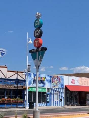
That said, I prefer the big colorful logo for ART (Albuquerque Rapid Transit). I’m sure that doesn’t date from the 1950s, but it’s definitely in the spirit of Googie/Wonderland/Jetsons design. They really hit a home run with those mid-century modern aesthetics!
My church’s gathering place calls itself Route 66 due to the 66 books of the Bible. It features a sign and clock with Route 66 logos. Clever.
Indeed! Apparently (according to Claude), it was originally going to be Route 60, because all east-west trunk roads were multiples of 10, but the Commonwealth of Kentucky objected: that number was “reserved” to represent a trunk road that would link the east coast (out toward Virginia Beach) westward through Kentucky. “66” was deemed easy to remember. Nothing Biblical I’m afraid, but then, with the Apocrypha, there’s probably a “Kentucky” out there among Bible scholars too!
This was the mural in ‘17
https://snipboard.io/EsXwPQ.jpg
Interesting. Is this at the UNM Computing Building? It must not have been there that long. They apparently painted over it in the intervening years. I can’t find any archived Street View photos that show it as anything other than a blank white wall.
I wonder what made them decide to remove that mural you’re showing. Or was your mural somewhere else nearby?
Yes, I know it’s a Mural in the right town. I don’t know if it’s the building you’re referring too. Just stayed in that town overnight on our 66 trip in ‘17? Was just driving around saw the mural and took the pic?
Got it. At first I thought your mural might have been painted over. So it might still be there.
Thanks for not trashing on our town, especially since you most likely saw some of the most unsavory areas of Central/Route 66. Also, glad you posted a pic of the homie’s skateshop: Kingswell.
Considering that there have been multiple times over the last few years where I have contemplated moving to the area, it would be pretty disingenuous for me to trash it! Having lived in a few megalopolises, metro Albuquerque-Santa Fe feels like the perfect size: all the offerings of a major city (and, yes, all the problems, but they go hand-in-hand), but not yet big enough to feel like a massive world of strangers. I’ve been three times.
Sure, I saw some pretty distressed homeless in the area, but that’s nothing new under the sun in 2026. Nob Hill still had the laid-back walkability of a college town, so if this is “most unsavory” you’re not doing so badly. Correct me if I’m wrong, but isn’t the rougher area a fair amount further east along Central?
And honestly, the per-capita representation of good coffee shops in ABQ is so much better than in northern Virginia, the place will always stay in my good graces.
You are correct in that east Central (but really only a few blocks) are rough.
I’ve lived here a long time and have truly grown to love the region and everything that comes with it: the variety of geology and biology, the history that is still present, the food, the open skies and a horizon that can be miles and miles away, the laid back attitude, the multiple cultures that are present and represented, and there’s a bitchin’ sunset just about every night.
Albuquerque actually has double the fun regarding Route 66, as the pre 1937 route travelled north-south through the city. The Central Avenue route was the second route through the city.
Ah, it sounds like you are aware of Route 66 arcana: good for you! I only learned about Santa Fe being part of the original path through my research on this specific article. Previously I had no idea. I considered mentioning it in this article but it was already getting long, and frankly, the “Santa Fe Loop” is interesting enough to merit a whole article unto itself. Political vengeance from the governor who didn’t get a second term (due largely to opposition in the state capital), so he rushed the construction of a new spur from Santa Rosa directly west into Albuquerque, which frankly was more convenient anyway. The Route 66 recognized the “Santa Fe Cutoff” was in fact more direct and practical and adopted it in 1937 as you noted. From what I can tell, the original Route 66 segment that linked Santa Rosa to Santa Fe was allowed to decay and nary a trace exists today.
Incidentally, Albuquerque at that time wasn’t that much bigger than Santa Fe, which was founded a century earlier that the Duke City (oldest state capital in the country). At the 1930 Census, Santa Fe had a little over 11,000 people and ABQ had 26,000. In the ensuing decades, Santa Fe grew slowly and Albuquerque surged. It’s hard not to imagine the advantage in accessibility and visibility afforded to Albuquerque through Route 66, while Santa Fe somewhat stagnated by comparison.
I also think it’s funny how Route 66 (Central Avenue in Albuquerque) generally moves in a straight path but takes this strange northwest detour so it can skirt the edge of Old Town Albuquerque, then snaps back to its original bearing. Perhaps that reflects part of the north-south path of the original Route 66 before the Santa Fe Cutoff took over.
https://snipboard.io/IQ30Si.jpg
https://snipboard.io/U6zhfq.jpg
That first one is just as nice-looking as (if less famous than) this one! https://dirtamericana.com/2019/10/fabulous-las-vegas-farewells/